Indian Ocean Tsunami Presentation
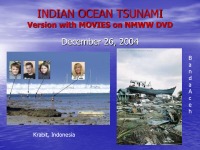
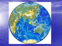

Indian ocean tsunami. version with movies on nmww dvd. Tsunami waves. Alfred Wegner observed. Earthquakes since. Mag 9, 0. 58 GMT, 10 km Deep, 250 km SSW. Facts model – pmel - titov. Depth Gauge Record of Mercator anchored 1 mile from coast of Phuket, Thailand. Jason 1 Altimetry Satellite Tracks. Minute Period. Banda Aceh City, Sumarta. Digital Globe. Satellite. Photos. Tug Boat and Barge. Cement Plant and Survivor. Phuket, Thailand. Phi Phi, Thailand. Phi Phi After Tsunami. Phi Phi Don. Trinkat, Nicobar-Andaman Islands. Khao Lak. South India After Tsunami. Digital Globe Satellite Photos. Sri Lanka After Tsunami. Train traveling from Colombo to Galle hit. Telwatta, Sri Lanka Train. Over 800 were Killed- Train 200 yards from shore. Sri Lanka. 10 meter Regions. in Red. Maldives islands – b. keating study. Location Map. Metal Roofing Cut People. Walls carried by flood. injured people. Maldives After Tsunami. Pacific tsunami warning center. ewa beach, hawaii. Wc/atwc - palmer, alaska. Wc/atwc. Earthquake Data Processing. Sea Level Data Display and Analysis. Far-Field Prediction Approach. Conclusions. Tsunami Warnings.
- Geography Presentations
- MS PowerPoint 3125 KB
- 2018 m.
- English
- 83 pages (1034 words)
- University
- Jonas


